
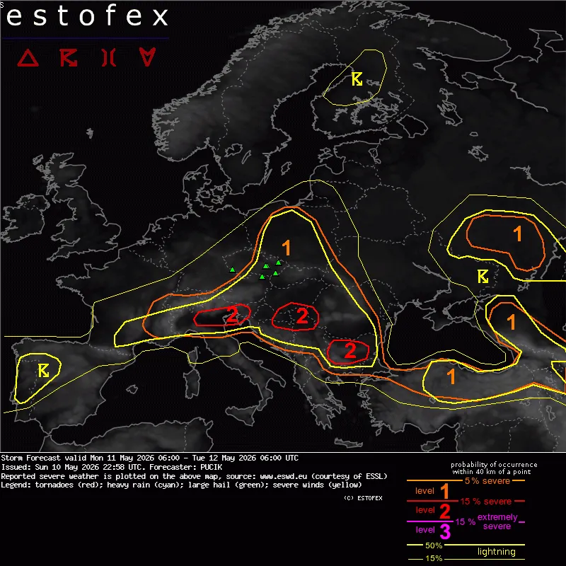
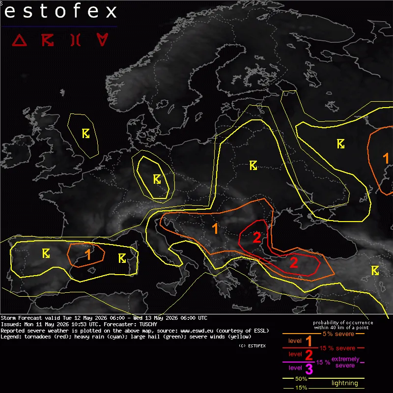
Severe storms continue from the Adriatic into the Balkans, Level 2 risk shifts toward Bulgaria, Romania and NW Turkey
Severe thunderstorms continued across parts of northern Italy, Slovenia, Croatia, and the western Balkans on Monday, May 11, 2026. ESTOFEX forecasters warn the severe weather corridor is expected to shift east on Tuesday, with Level 2 risk areas extending from southeastern Romania through Bulgaria into northeastern Greece and northwestern Turkey. Large hail, localized heavy rainfall, and severe wind gusts remain the primary hazards.
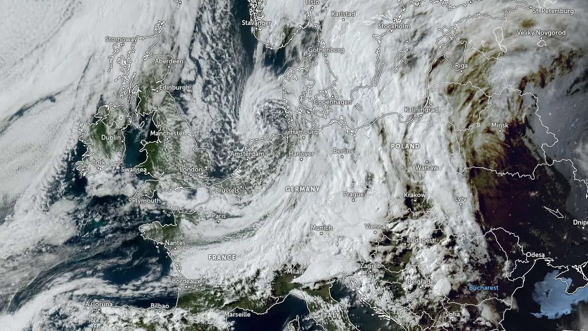
Satellite image of Europe acquired at 16:50 UTC on May 11, 2026. Credit: EUMETSAT/Meteosat, Zoom Earth, The Watchers
A broad upper-level trough crossing central and southeastern Europe continues to support organized convection across multiple regions. During the ongoing May 11-12 forecast period, forecasters at the European Storm Forecast Experiment (ESTOFEX) highlighted northeastern Italy, western Slovenia, Istria, eastern Croatia, and parts of Serbia for supercells capable of producing large hail, severe wind gusts, and isolated tornadoes.
The highest tornado potential was identified near the northern Adriatic region, where enhanced low-level shear overlapped with moist trajectories from the Adriatic Sea.
Storms developing across Slovenia and far northeastern Italy during the morning hours were forecast to evolve into clusters and progressive mesoscale convective systems while spreading southeastward across Croatia, northern Bosnia and Herzegovina, and Serbia.
Embedded supercells and localized severe wind swaths remain possible within the broader convective complex, although forecast discussions noted uncertainty regarding the precise corridor of strongest wind gusts due to storm-scale processes and convective evolution.
As the trough progresses eastward, the primary severe-weather corridor is forecast to shift toward southeastern Europe during the May 12-13 period. A Level 2 severe weather area covers parts of southeastern Romania, Bulgaria, northeastern Greece, and NW Turkey, where a combination of moderate instability and strengthening deep-layer shear is expected to support organized multicells and isolated supercells.
ESTOFEX uses a three-level severe-weather scale, with Level 1 marking a lower-probability severe risk, Level 2 marking a higher-probability severe risk, and Level 3 reserved for the highest severe-weather risk.
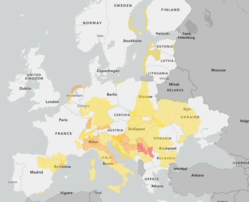
While most of Europe is under Yellow and Orange warnings on Monday, May 11, Tuesday brings Red wind warnings for Western Serbia, Srem, Sumadija, and Eastern Serbia.
“Great damage and accidents are possible. Such meteorological hazards can be very dangerous to the security of people and animals,” RHMS Serbia said, urging residents in affected regions to keep themselves informed about the details of expected meteorological conditions and risks. “Follow the orders, instructions, and advice given by the authorities.”
Across Bulgaria and southeastern Romania, the atmosphere is forecast to contain enough instability for strong, sustained updrafts, while winds changing speed and direction with height should help storms organize. Forecasters said this setup supports large to isolated very large hail. Damaging wind gusts are also possible where storms move into drier, warmer low-level air that can accelerate downdrafts toward the ground.
Farther south and east, the Level 2 area extends into northeastern Greece and NW Turkey, where increasing shear and locally favorable instability may support severe hail and damaging winds if storms develop.
Forecast discussions noted uncertainty regarding convective initiation across far NW Turkey, although terrain interaction and storm clustering could increase the heavy-rain threat later in the period.
A surrounding Level 1 risk area extends from Slovenia and Croatia into Bosnia and Herzegovina, Serbia, and parts of Romania, where organized thunderstorms capable of producing hail, gusty winds, heavy rainfall, and isolated tornadoes remain possible. Additional Level 1 areas were issued for northeastern Spain, parts of western Russia, and sectors of eastern Poland, Belarus, and western Ukraine.
Across northeastern Spain, a short-wave trough and favorable upper-level jet dynamics are forecast to support scattered multicells and isolated supercells capable of producing 2 to 3 cm (0.8 to 1.2 inches) hail, severe gusts, and bursts of heavy rainfall. Forecasters noted that the severe risk may gradually decrease offshore as convection becomes increasingly elevated within the cooling footprint of the Mistral flow.
Parts of eastern Poland, Belarus, and western Ukraine may also experience scattered thunderstorms within a moist and weakly unstable air mass, although weak vertical shear is expected to limit storm organization. Heavy rainfall and isolated gusts remain the primary hazards there, with only a low-end tornado threat discussed.
The pattern reflects a typical late-spring transition toward increased severe thunderstorm activity across southeastern Europe and the western Black Sea region, where strengthening instability and upper-level dynamics frequently support organized convection, large hail, and mesoscale convective systems.
References:
1 Storm forecast – Threat Level 2 – ESTOFEX – May 11, 2026
I'm a dedicated researcher, journalist, and editor at The Watchers. With over 20 years of experience in the media industry, I specialize in hard science news, focusing on extreme weather, seismic and volcanic activity, space weather, and astronomy, including near-Earth objects and planetary defense strategies. You can reach me at teo /at/ watchers.news.
Commenting rules and guidelines
We value the thoughts and opinions of our readers and welcome healthy discussions on our website. In order to maintain a respectful and positive community, we ask that all commenters follow these rules.